Hello,
I’m with the science party of the R/V Endeavor and we’re about to head
offshore for the NESBA TFO experiment starting on Sat. 4/24. We were hoping
to use some of the telemetered data from the Coastal Pioneer Array during
our time at sea to guide our sensor placement. Specifically, we would want
the CTD data from the profiler moorings.
We noticed recently that the telemetered data haven’t been updated since
April 12. I was wondering if there were any issues with the array that may
be causing the delay?
Thanks,
Drew Wendeborn
Portland State University ECE
Our Pioneer 16 cruise, which included a turn of all Pioneer moorings, concluded on Friday 4/16/21. Leg 1, which included a turn of the Coastal Surface Moorings and gliders, concluded on 4/6/2021. Data for these platforms were ingested and available in OOINET by 4/8/2021. Leg 2, which included a turn of the Profiler Moorings, concluded on 4/16/21 and data were ingested and available in OOINET by 4/19/2021. Unfortunately, CP02PMCO has an Iridium communications issue and is not telemetering data. We believe the profiler is functional and collecting data, but at this point we do not expect any telemetered data for the deployment. Please let us know if you have any issues or questions about accessing the data.
Colin —
We all had another quick question about OOI mooring data as follows. Why is it that the profiles do not span the full water column from near the surface to near the seabed depth? And what causes the range of depths surveyed to occasionally change?
We’re asking since for Navy submarine applications sounds speeds from the surface to near the seabed (or to a max of 500m or so) are all important.
Thanks,
Bill Stevens
Portland State University
Research Associate
Hi Bill,
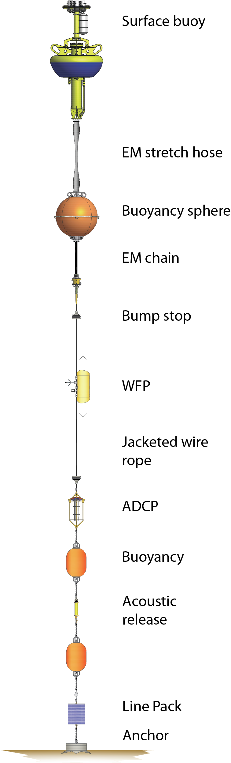
The mooring design, with recoverable anchors and subsurface flotation, precludes the profiler from covering the full water column depth. A representative diagram is attached.
The profilers do not always achieve their full programmed depth (i.e. do not completely cover the expected depth range) due to slippage of the traction motor on the wire. This can be caused by many factors, such as wave action, currents,
buoyancy changes and fouling.
Thanks,
Collin!
Coastal Profiler Mooring|151x500
Hi Bill and Drew,
We also deployed 2 Slocum Gliders to the Pioneer array that may be of interest. These gliders, CP05MOAS-PG564 & CP05MOAS-PG583, are deployed to help fill the void that is left when the CNPM and ISPM profiler moorings are recovered in the Spring. These gliders are loaded up with sensors including a CTD, 2 Wet Labs pucks, Oyxgen Optode, SUNA Nitrate Sensor, and a PAR. More info on these gliders and sensors can be found here: CP05MOAS – Ocean Observatories Initiative. Their telemetry schedule is also slightly different than the profiler moorings as they surface and telemeter data every 8 hours.
Data for these gliders can be found in OOINET: Data Access & Visualization
and also the IOOS Glider DAC: IOOS Gliders Map - Catalog
Take care,
Collin
Hi Drew,
Curiously I am at this moment testing the M2M R program written by Ian Black to query and ingest the last few months of CTD data from the Offshore upstream profiler mooring. There’s a ring or meander there now. This is telemetered temperature data up until midnight last night.
-Bob.

